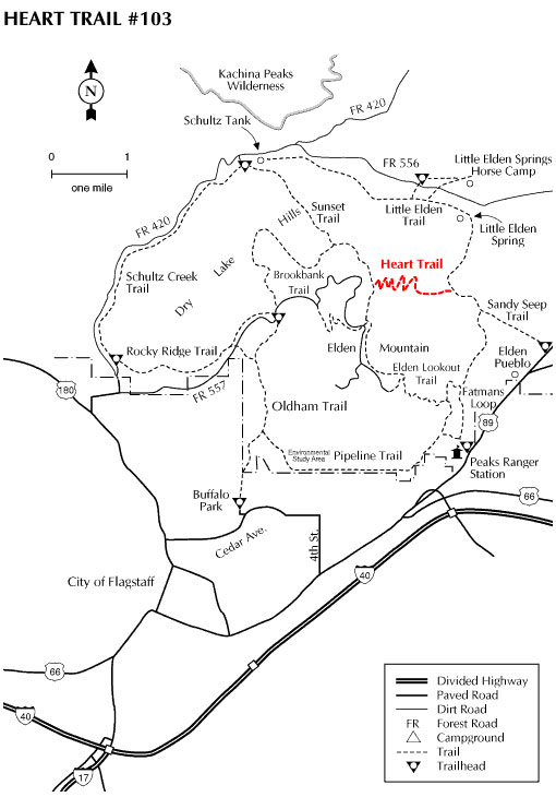
The Heart trail begins in the Sandy Seep area just north of Flagstaff at approximately 7200 feet, and climbs the east slope of Mt. Elden to connect with the Sunset Trail in Sunset Park. As the trail climbs, it winds through the remnants of a large mixed conifer forest which was destroyed by the Radio fire in 1977. The area is well into regeneration, with gamble oak and various grasses and shrubs growing strong.
The Heart Trail can be accessed from a number of trails: the Little Elden Trail, the Sandy Seep Trail and the Sunset Trail. (The Google Map shown below shows Sandy Seep Trailhead.)
At a Glance
Usage:
Light
Best Season:
April thru November
Closest Towns:
Flagstaff, AZ
Operated By:
Flagstaff Ranger District - 928-526-0866
General Information
Directions:
USGS Map: Sunset Crater West
Location: North of Flagstaff on graveled Forest Roads.
Access: The best access to the Heart Trail, would be to begin at the Sandy Seep trailhead. This is approximately 1.5 miles north of the Flagstaff Ranger District on Highway 89, just past Elden Pueblo, on the west side of the highway. The trail is within the incorporated boundaries of Flagstaff, and can be reached by the Fatman Loop Trail and the Little Elden Trail. Equestrian parking is limited, but additional equestrian parking is located at the trailhead west of the Little Elden Spring horse camp on FR 556.
General Notes:
Area/Length : 2.0 miles
Latitude : 35.249987
Longitude : -111.561920
Elevation : 7200' - 8500'
Rating: Strenuous
Hiking time: 2.5 hours
Notes:
This is a multi-use trail, but due to the difficulty, it is not suggested for mountain bike users.
An equestrian water source is located at Shultz Tank.