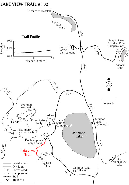
There's an excellent view of Mormon Lake and the forested volcanic hills that surround it waiting for you at a scenic overlook along this moderate, 2 mile hike. Lake View Trail climbs gradually, through a stand of ponderosa pines, to the top of a rugged rock outcrop that stands high above the surrounding countryside. This rocky promontory offers panoramic views of lake and meadow, forests and mountains.
Trailside log benches at the overlook make it a comfortable spot for a lunch with a view. While you're there, notice that this high cool place is home to a number of plants that we more readily associate with a desert environment. Tucked among the rocks at the overlook you'll find broadleaf yucca and a couple of different kinds of hedgehog cactus-watch where you step and especially where you sit.
From here you can continue on to trail's end at Winsor Tank. There you'll find aspen groves and a green mountain meadow that's a good place to happen upon elk or mule deer browsing in the open.
At a Glance
Usage:
Medium
Best Season:
April thru November
Closest Towns:
Mormon Lake, AZ, Flagstaff, AZ
Operated By:
Flagstaff Ranger District - 928-526-0866
General Information
General Notes:
Rating: Easy
Notes: No motorized vehicles
Area/Length : 2.0 miles
Latitude : 34.941602
Longitude : -111.493450
Elevation : 7169'
Directions:
USGS Maps: Mormon Lake, Mormon Mtn.
Location: About 24 miles (45 minutes) southeast of Flagstaff, just north of Mormon Lake.
Access: Drive south from Flagstaff 20 miles on Forest Highway 3 (Lake Mary Road) to the Forest road 90 intersection. Turn west on FR 90 and drive 4.6 miles to Double Springs Campground. The trailhead is at the south end of the campground. All roads are paved and open year-round.