Arizona's Best Swimming Holes  


Rocky Ridge Trail #153

Upload GPS Tracks
Upload Trail Photos
Trail Ratings
Overall Trail Rating
1 = Poor 5 = Outstanding

Scenic Views
 
Route Finding
1 = Poor 5 = Excellent
 
Technical Difficulty
1 = Easy 5 = Very Difficult
 
Trail Access
1 = Easy 5 = Hard to get to
 

This rocky path over rolling terrain leads through a forest of ponderosa pines interspersed with stunted Gambel oaks and gnarled alligator junipers. Also found on this arid south slope of the Dry Lake Hills are a number of hardy shrubs and ground hugging desert plants. Among these are cliffrose, broadleaf yucca and prickly pear cactus. Combined they add a bit of desert ambiance to the surroundings. In season, colorful wildflowers add a splash of brightness to the rocky slopes. From mid-spring to late summer along the trailside you'll see a number of varieties of paintbrush, a creamy yellow flower called butter and eggs and lots of bright red penstemon.

Though this trail is quite close to town, evidence of wildlife is none the less common. The tracks of coyote and elk are frequently mixed in with the tracks of joggers, hikers and mountain bikers. In mid-summer the sweet notes of the area's resident songbird, the hermit thrush echo through the forest. As the trail roller coasters over the shallow dry washes that crease the lower slopes of the Dry Lake Hills it offers good views of Flagstaff and its western suburbs. The upper reaches of Oak Creek and Sycamore Canyons are visible in the background. So is Mormon Mountain.

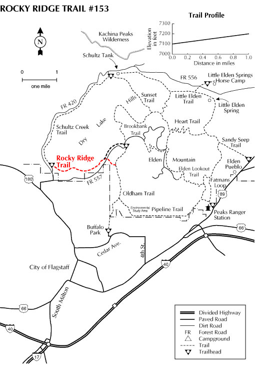
Rocky Ridge Trail provides a convenient connecting route between Schultz Creek Trail and the Oldham Brookbank trails.

Photos & Multimedia

At a Glance

Usage: Medium
Best Season: Early spring to late fall
Closest Towns: Flagstaff, AZ
Operated By: Flagstaff Ranger District - 928-526-0866

General Information

Directions:

USGS Map: Humphreys Peak, Flagstaff West

Location: Just north of Flagstaff off US 180

GPS: N35° 14' 37.6434", W-111° 39' 41.364"

Access: Drive north from Flagstaff 2 miles on US 180 to FR 420 (Schultz Pass Road). Turn east and follow FR 420 about a mile to a gate and cattle guard. Turn right down over the hill toward Schultz Creek and park. The trailhead is marked with a sign near the creekbed.

General Notes:

Rating: Easy

Hiking time: 1 hour

Notes: No motorized vehicles

Area/Length : 2.2 miles

Latitude : 35.246803

Longitude : -111.664016

Elevation : 7100 - 7206

Rocky Ridge Trail #153


Comments

comments powered by Disqus


Camping Regions
Camping Regions

Central Arizona
Flagstaff / Sedona / Prescott
Northeast / Grand Canyon
Payson / Mogollon Rim
Southeast / Tucson
White Mountains
Western Arizona


Camping
Resources

Camping Checklist
Camping Gear
Our You Tube Videos
Camping Recipies

Arizona Game and Fish Department

Fishing Reports
Lake Levels
Stocking Schedule
AZ Fishing Rules & Regulations
Where to Fish
Sport Fish Species
Urban Fishing

U.S. Forest Service
National Forests in Arizona

Apache Sitgreaves N.F.
Coconino N.F.
Coronado N.F.
Kaibab N.F.
Prescott N.F.
Tonto N.F.


Site Map
Advertising Information
Contact Us
Links


All campground rates and information are subject to change without notice.


Home | Campgrounds | Hiking Info |Camping Checklist | Fire Information
Western Arizona RV Parks | Fishing Reports | Contact Us | Links
Site Map

All original material and HTML coding © 2004-2021 camparizona.com

Terms of Service | Privacy Policy


Arizona Game and Fish Department U.S. Forest Service