The rather unique name for this trail comes from a sheepherder who once lived in the area and was as good at clipping his fellow herders as he was at shearing woolies.
Barbershop Trail meanders through a pleasant region of open forests and shallow canyons and provides an excellent place to enjoy a woodland stroll or a weekend backpack. You'll find a wide variety of tree species here, including maple, aspen and oak, scattered among the more typical ponderosa pine and Douglas fir. The high proportion of deciduous trees makes this trail an especially colorful place in the fall, but there's plenty of wildlife to see at all seasons of the year. Watch for wild turkey, mule deer and elk. There are black bear in the area too, but they're much harder to see. Especially while you're so busy enjoying the scenery.
Rating: Moderate
Hiking time: 2 hours
Notes:
No motorized vehicles. There is water on this trail.
At a Glance
Open Season:
April
Usage:
Medium
Closest Towns:
Happy Jack, AZ
Operated By:
Mogollon Rim District - 928-477-2255
General Information
Directions:
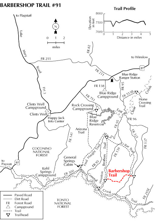
Location: 77 miles (about 2 hours) southeast of Flagstaff in the cool pines of Mogollon Rim country.
Elevation: 7549' at east trailhead
Length: 4.5 miles
USGS Maps: Dane Canyon
GPS:
East Access Trailhead - 34° 26.599' 111° 08.495'
West Access Trailhead - 34° 26.349' 111° 11.950'
Access:
East Access - Drive about 55 Miles south of Flagstaff on Forest Highway 3 (Lake Mary Road). Turn north on AZ87 and travel 9 miles to FR95, turn right on FR95 and follow to function of FR96 at the East Clear Creek. Travel on FR96 to FR137, turn right and go south to the Buck Springs Cabin to trailhead.
West Access: Drive 55 miles south of Flagstaff on FH3 (Lake Mary Road). Turn left and travel 9 miles on AZ87 to FR95. Turn right on FR95 and travel 8 miles to FR139. Continue 7 miles on FR139 to trailhead.