This historic trail is part of the Cabin Loop Trail system. It was named after a rancher who once used it to move cattle and supplies from ridge to ridge and valley to valley in the roadless wilderness above the Mogollon Rim. Today it provides hikers and horsebackers access to this scenic area of shallow canyons and forested ridges.
The Fred Haught trail was almost lost to neglect after a system of ridge top roads replaced it as the main route for commerce and travel in the 1950's. However, a renewed interest in the area by recreationists and history buffs inspired its recent reopening.
You'll find a hike along this trail leisurely and scenic, with a good chance to see wildlife and ample opportunity to imagine what it must have been like when horses and trails were the only way of traversing this picturesque countryside.
The monument of the Battle of Big Dry Wash shown above is just off of FR 300 at the beginning of the Fred Haught Trail.
Rating: Moderate
Hiking time: 3 hours
Notes:
No motor vehicles.
Be prepared to follow blazes, the path is faint and hard to see.
The last half of the Fred Haught is not maintained.
There is water on this trail.
GPS: Trailhead - N34° 29.227', W-111° 13.718'
Pinchot Cabin - N34° 30.393', W-111° 11.672'
General Springs - N34° 27' 30.8154", W-111° 15' 4.4634"
At a Glance
Open Season:
April
Usage:
Medium
Closest Towns:
Happy Jack, AZ
Operated By:
Mogollon Rim District - 928-477-2255
General Information
Directions:
Latitude: 34.487098
Longitude: -111.228639
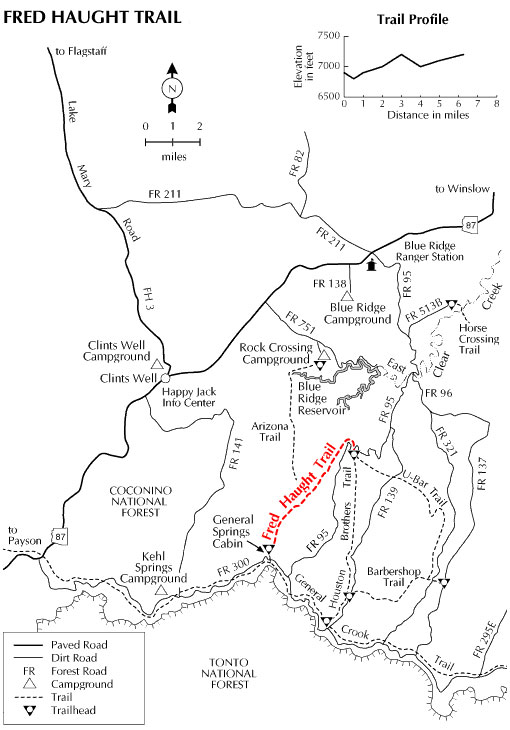
Area/Length: 6 miles
Elevation: 6892' at trailhead
USGS Maps: Blue Ridge Reservoir, Dane Canyon
Location: 65 miles (about 2 hours) south of Flagstaff in the cool pines of Mogollon Rim country.
Access: Drive about 55 Miles south of Flagstaff on Forest Highway 3. Drive north 9 miles on AZ 87 to FR 95. Turn south (right) about 8 miles to FR 139A. Turn left on 139A to the trailhead. FH 3 and AZ 87 are paved. FR 95 is graveled and suitable for passenger vehicles except during winter when it is closed.