Arizona's Best Swimming Holes  


Pine Canyon Trail #26

Upload GPS Tracks
Upload Trail Photos

Trail Ratings
Overall Trail Rating
1 = Poor 5 = Outstanding

Scenic Views
 
Route Finding
1 = Poor 5 = Excellent
 
Technical Difficulty
1 = Easy 5 = Very Difficult
 
Trail Access
1 = Easy 5 = Hard to get to
 

Only a short portion of this trail is on the Coconino National Forest, proceeding over the edge of the Mogollon Rim, with the longest portion on the Tonto National Forest. This trail offers a scenic view of Pine, Arizona and surrounding area. Ferns grow along the banks of Pine Creek. Trailhead sign also presents distances to other trails nearby.

Length: .05 on the Coconino, 7.5 miles on the Tonto

Rating: Moderate/Difficult

Elevations: Beginning: 7200, Ending: 5000. High/Low Points: 7240/5000 feet.

At a Glance

Open Season: Spring
Usage: Medium
Closest Towns: Payson, Pine, Strawberry, AZ
Happy Jack, AZ
 
Operated By: Mogollon Rim District - 928-477-2255
Information Center: 
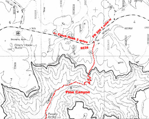
The sign for FR 6038 is difficult to see as it is behind the fence and back from Highway 87

General Information

Latitude: 34.451102

Longitude: -111.417494

Area/Length: 8 miles

Elevation: 7244' at Coconino TH

Directions:

USGS Maps: Buckhead Mesa and Pine

Location: Southeast of Flagstaff

Access: From Clints Well go south on Highway 87 approximately 10.8 miles, to FR 6038. This road is approximately 1 miles south-west of FR 300 and about 2 miles north-east of Cinch Hook Snowplay area. Turn left. Road is gated with poles and barbed wire. Please reclose the gate. Trailhead is 0.1 mile on the left. Follow the signs to Dripping Springs then on to Pine Trailhead.

Pine Canyon Trail #26 Map


Comments

comments powered by Disqus


Camping Regions
Camping Regions

Central Arizona
Flagstaff / Sedona / Prescott
Northeast / Grand Canyon
Payson / Mogollon Rim
Southeast / Tucson
White Mountains
Western Arizona


Camping
Resources

Camping Checklist
Camping Gear
Our You Tube Videos
Camping Recipies

Arizona Game and Fish Department

Fishing Reports
Lake Levels
Stocking Schedule
AZ Fishing Rules & Regulations
Where to Fish
Sport Fish Species
Urban Fishing

U.S. Forest Service
National Forests in Arizona

Apache Sitgreaves N.F.
Coconino N.F.
Coronado N.F.
Kaibab N.F.
Prescott N.F.
Tonto N.F.


Site Map
Advertising Information
Contact Us
Links


All campground rates and information are subject to change without notice.


Home | Campgrounds | Hiking Info |Camping Checklist | Fire Information
Western Arizona RV Parks | Fishing Reports | Contact Us | Links
Site Map

All original material and HTML coding © 2004-2021 camparizona.com

Terms of Service | Privacy Policy


Arizona Game and Fish Department U.S. Forest Service