Arizona's Best Swimming Holes  


Soldier Trail #21

Upload GPS Tracks
Upload Trail Photos

Trail Ratings
Overall Trail Rating
1 = Poor 5 = Outstanding

Scenic Views
 
Route Finding
1 = Poor 5 = Excellent
 
Technical Difficulty
1 = Easy 5 = Very Difficult
 
Trail Access
1 = Easy 5 = Hard to get to
 

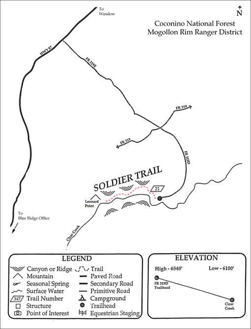
The Soldier Trail provides access into the bottom of East Clear Creek. Once in the bottom of the creek the trail turns west for about three-quarters of a mile before ascending the west canyon wall of the creek. The trail is very difficult to hike and may not be passable during high water. The section of the trail along the creek is not well marked.

The area is quite scenic and offers excellent photographic opportunities. In addition, sometimes outstanding trout fishing opportunities are available in East Clear Creek.

Elevation: 6,540 to 6,100

Rating: Moderate to Difficult

Notes:

  • No motor vehicles are permitted.
  • The road to the trailhead is marked with a new sign.

At a Glance

Open Season: Spring
Usage: Light
Closest Towns: Happy Jack, AZ
Operated By: Mogollon Rim District - 928-477-2255

General Information

Latitude: 34.644117

Longitude: -111.006124

Area/Length: 2 miles

Elevation: 6549 at trailhead

Directions:

USGS Maps: Quayle Hill

Access: Soldier trail is located at the end of fire road 319D. Access to the trail head is limited; as a result the trail receives limited use. Suggestions for maintenance of this trail are few, because of low visitation and a desire to maintain the trail in a semi-wilderness condition.

Soldier Trail #21


Comments

comments powered by Disqus


Camping Regions
Camping Regions

Central Arizona
Flagstaff / Sedona / Prescott
Northeast / Grand Canyon
Payson / Mogollon Rim
Southeast / Tucson
White Mountains
Western Arizona


Camping
Resources

Camping Checklist
Camping Gear
Our You Tube Videos
Camping Recipies

Arizona Game and Fish Department

Fishing Reports
Lake Levels
Stocking Schedule
AZ Fishing Rules & Regulations
Where to Fish
Sport Fish Species
Urban Fishing

U.S. Forest Service
National Forests in Arizona

Apache Sitgreaves N.F.
Coconino N.F.
Coronado N.F.
Kaibab N.F.
Prescott N.F.
Tonto N.F.


Site Map
Advertising Information
Contact Us
Links


All campground rates and information are subject to change without notice.


Home | Campgrounds | Hiking Info |Camping Checklist | Fire Information
Western Arizona RV Parks | Fishing Reports | Contact Us | Links
Site Map

All original material and HTML coding © 2004-2021 camparizona.com

Terms of Service | Privacy Policy


Arizona Game and Fish Department U.S. Forest Service