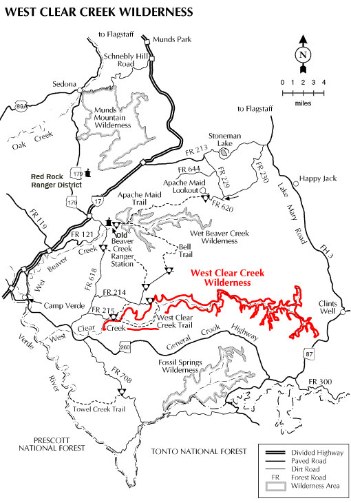
In an isolated corner of the Coconino National Forest, Willow and Clover Creeks flow together to create West Clear Creek. Several writers have described this stream as one of the most remote and beautiful in the American Southwest. The canyon that the creek has cut into the southern edge of the Colorado Plateau is so deep and narrow that to proceed down it one is required to wade or swim as many as 15 to 20 pools that stretch from canyon wall to canyon wall. Some are as long as a quarter mile.
It goes without saying that any place this remote and inaccessible provides superior opportunities for solitude and primitive recreation. For most of its length the stream is a valuable fishing resource, too, and is stocked with trout by the Arizona Game and Fish Department. Trails leading into the canyon from the rim attract hardy adventurers seeking good fishing and secluded swimming holes. Trails that lead up from the canyon mouth get a lot of use by weekend anglers, backpackers, and car campers who use the primitive camping area near Bull Pen Ranch (see map on Blodget Basin Trail Page) as a starting point.
The image above was taken overlooking the canyon just west of Hwy 87. The lat/long is 34.562859 -111.388930. Click image for full-size view. This little slice of heaven is on the eastern end of West Clear Creek Wilderness.
At a Glance
Open Season:
Year 'round
Closest Towns:
Sedona, AZ and Happy Jack, AZ
Operated By:
Red Rock and Mogollon Rim Districts
General Information
Directions:
Location: 52 miles south of Flagstaff and 12 miles east of Camp Verde off paved and graveled roads some of which can be a bit rough.
Access: The lower areas of this remote canyon are accessible via a number of roads and trails, including FR's 214 and 215 off FR 618 (see scenic drives)., Upper reaches of the canyon are accessible via the Maxwell and Tramway trails off FR's 81 and 81E.
General Notes:
Attractions: Trails for hiking and horseback riding, Swimming, Fishing, Great views, Photography, Wildlife viewing
Notes:
Mechanized vehicles, including mountain bikes, are not permitted in the Wilderness.
This area can be quite hot in summer but the stream flows year-round.
Hikes in the canyon's middle reaches require swimming long deep pools between sheer canyon walls.
Trails in the Wilderness: Blodgett Basin #31, West Clear Creek Trail #17 , Maxwell Trail #37, Tramway Trail #32.