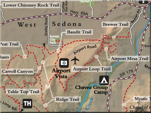
Airport Loop/Table Top Trails #211/212, Bandit Trail, Brewer Trail
The trail circles the upper slope of Airport Mesa (Table Top Mountain), described clockwise here. There is no shade until reaching the last mile where it is intermittent depending on season and time of day. From the parking area, climb to the southeast about 100 yards to the top of the small saddle (Airport Saddle- GPS coordinates: N34° 51' 24.2274", W-111° 46' 45.912").
Turn right to pick up the trail which immediately bends to the left to follow the southeast slope of the mesa. There are great red rock views from northeast to south over lower Oak Creek Valley. It is a mostly level trail for the first mile and then it begins a gradual and then moderate ascent over basalt boulders to the top of the south corner of the mesa at 1.4 miles. The trail levels out, turns north and follows the airport perimeter fence for a time. It drops down to cross a small wash and climbs out to the west where it intersects the Table Top Trail at 1.7 miles.
The Table Top Trail is a half-mile (one-way) spur which climbs gradually on a finger of land extending to the southeast. It ends at at point with great panoramic views taking in the Red Rock Loop Road area to the west and many of the area's most noted formations all around. Return by the same route to the main trail and continue north. Soon, the trail begins a moderate descent and turns to the northeast. Just past the 2 mile mark, the trail intersects the top of the Bandit Trail on the left which leads down into West Sedona. As you continue ahead, the trail descends some more and levels out after a switchback. The final stretch of the trail is a gradual climb eastward.
The views here are over West Sedona and of Capitol Butte and Wilson Mountain. (Click here for larger view of West Sedona from Ariport Road.) The trail ends at Airport Road across from the starting point at the parking turnout.
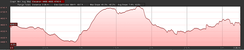
Hiking time: allow 2.5 hours for round trip
USGS Maps: Sedona
Notes:
No horse trailer parking.
For more information contact:
Coconino National Forest, Red Rock Ranger District, P.O. Box 20429, Sedona AZ 86341, (928) 203-2900
At a Glance
Open Season:
Year 'round
Usage:
Light-Medium
Operated By:
Red Rock Ranger District - 928-203-2900
General Information
Latitude: 34.85547
Longitude:-111.78070
Area/Length: 4.3 mile loop including Table Top Spur
Elevation: 4586 - 4740
Directions:
From the junction of Routes 89A and 179, take 89A west 1.0 miles to Airport Road on the left. Go .5 miles and park in the turnout on the left.