Arizona's Best Swimming Holes  


Boynton Canyon Trail #47

Upload GPS Tracks
Upload Trail Photos

Download this GPS TrackRight Click and "Save Link As.."

Trail Ratings
Overall Trail Rating
1 = Poor 5 = Outstanding

Scenic Views
 
Route Finding
1 = Poor 5 = Excellent
 
Technical Difficulty
1 = Easy 5 = Very Difficult
 
Trail Access
1 = Easy 5 = Hard to get to
 

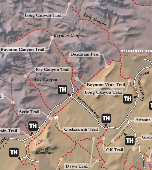
Boynton Canyon is one of the most scenic of the box canyons that make Arizona Red Rock Country so famous. This particular trail enjoys the additional advantage of being conveniently accessible to nearby towns on well paved roads. As you might suspect, that is both good and bad news for those who choose to come here. The good news is you don't have to bounce down a dusty jeep track to get to the trailhead. The bad news is you may have more company than you hoped for when you arrive.

Boynton Canyon always has been popular for its outstanding scenery. Lately it has become even more so, since it developed a reputation as a site of a New Age "vortex" - a sort of energy field emanating from inner earth. Whether or not you subscribe to this bit of modern mysticism, you'll no doubt agree that some sort of magic exists here among the towering buttes, crimson cliffs, and natural desert gardens.

The trail starts out by skirting a luxury resort that was recently built here. It quickly returns to the canyon floor where the walking is pleasant and easy. As you hike, take note of the variety of plants that live in this rather harsh environment, and keep an eye out for the area's plentiful wildlife which includes everything from colorful songbirds to bristling, shy whitetail deer.

See also: Deadmans Pass Trail and Long Canyon Trail

At a Glance

Open Season: Year 'round
Usage: Heavy
Closest Towns: Sedona, AZ
Restroom: Vault Toilet at Trailhead
Operated By: Red Rock Ranger District - 928-203-2900

General Information

Latitude: 34.907816

Longitude: -111.84906

Length: 2.5 miles

Elevation: 4521 at trailhead - 5256 at end

General Notes:

Rating: Easy

Hiking time: 2-2.5 hours

USGS Maps: Wilson Mt., Loy Butte

Notes:

  • No mechanized vehicles in Wilderness.
  • Respect private property boundaries.

Directions:

Location: 32 miles south of Flagstaff (2 miles west of Sedona) on paved roads.

GPS: N34° 54' 26.388", W-111° 50' 55.2114"

Access: Drive 27 miles south from Flagstaff to Sedona on US 89A. Continue through Sedona to Dry Creek Road at the southwest end of town. Turn north (right) on Dry Creek Road and follow the signs to Boynton Canyon. You'll find a parking lot and the trailhead just outside the entrance to the Enchantment Resort.


Parking:

The parking lot is paved with a vault-type toilet.


Accessibility:


Blodgett Basin Trail #31

Comments

comments powered by Disqus


Camping Regions
Camping Regions

Central Arizona
Flagstaff / Sedona / Prescott
Northeast / Grand Canyon
Payson / Mogollon Rim
Southeast / Tucson
White Mountains
Western Arizona


Camping
Resources

Camping Checklist
Camping Gear
Our You Tube Videos
Camping Recipies

Arizona Game and Fish Department

Fishing Reports
Lake Levels
Stocking Schedule
AZ Fishing Rules & Regulations
Where to Fish
Sport Fish Species
Urban Fishing

U.S. Forest Service
National Forests in Arizona

Apache Sitgreaves N.F.
Coconino N.F.
Coronado N.F.
Kaibab N.F.
Prescott N.F.
Tonto N.F.


Site Map
Advertising Information
Contact Us
Links


All campground rates and information are subject to change without notice.


Home | Campgrounds | Hiking Info |Camping Checklist | Fire Information
Western Arizona RV Parks | Fishing Reports | Contact Us | Links
Site Map

All original material and HTML coding © 2004-2021 camparizona.com

Terms of Service | Privacy Policy


Arizona Game and Fish Department U.S. Forest Service