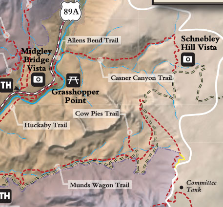
Bring your wading shoes for this one. You'll be wading clear, cool Oak Creek early in the hike. According to historians, this trail was built to provide cattle grazers a means of getting their stock from water on the canyon floor to pastures on the canyon rim. Today, it is used by hikers and horsebackers for access into the heart of a landscape most people see only through their telephoto lens.
After crossing Oak Creek, the trail leads a short way up the floor of Casner Canyon before turning up the canyon's north slope. It then continues a long and sometimes steep climb to the canyon rim about a half-mile north of the Schnebly Hill Road overlook. The route it follows is a scenic one, right through the middle of some of the rock formations that make up the spectacular view from Sedona and Highway 89A. Because shade is sparse, this can be a hard, hot climb on a sunny day. Bring lots of water along with your camera.
At a Glance
Open Season:
Year 'round
Usage:
Medium
Best Season:
April to November
Busiest Season:
Summer
Operated By:
Red Rock District - 928-203-2900
General Information
Latitude: 34.893297
Longitude: -111.733234
Length: 2 miles
Elevation: 4534 at trailhead
Directions:
Location: 25 miles south of Flagstaff (2 miles north of Sedona) on paved roads in scenic Oak Creek Canyon. Elevation is 4400 feet at the trailhead. Access: Drive 25 miles south from Flagstaff or 2 miles north from Sedona on US 89A. Park either on the west side of the highway across from a road blocked by a closed gate or at the Grasshopper Point recreation Area. If you park at Grasshopper, you'll have to follow Allens' Bend Trail to its intersection with Casner Canyon Trail. Allen's Bend Trail starts at the north end of the Grasshopper Point parking lot.