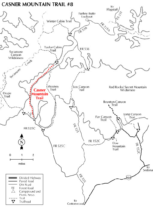
Originally built to maintain power lines, Casner Mountain trail offers spectacular views of the Sycamore Canyon and Red Rock/Secret Mountain Wildernesses and the Verde Valley. The trail follows an old jeep road which still provides access to the power lines.
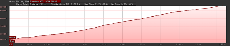
The trail begins in high desert vegetation and switchbacks up the side of Casner Mountain. Once on top of the mesa, pinyon/juniper with open grasslands are the norm. The ascent is very strenuous and accounts for about 2 miles of the total length. However, once on top the hike is really quite easy to moderate. Take lots of water especially during the summer months.
Wildlife is abundant, particularly in the winter months. Watch for elk and deer. An occasional bear and even mountain lion are spotted.
Rating: Moderate to strenuous
Hiking time: Plan on a full day/overnighter.
Notes: ATV maximum width is 50 inches. (ATVs and bikes must remain on the trail. Leaving the trail to either side would put you in the Wilderness areas where vehicles are not allowed.)
Captions for photos under "photos & multimedia" Closed Gate: Casner Mountain Trail Gates will generally be closed. You may take your ATV or bikes under this gate. If you have a permit for full-size four-wheeling, you will have the combination for this gate. The gate policy for this gate is an exception on this forest. Open Gate: Photo of the gate on Casner Mountain Trail open. This photo was sent by an ATV user who happened to run into a facility maintenance crew when he went to ride the trail and they opened the gate for him. Otherwise, he could have pushed his ATV under the gate.
General Information
Latitude: 34.923300
Longitude: -111.981300
Length: 7 miles
Elevation: 4837 at south trailhead
General Notes:
Directions:
Location: About 48 miles south of Flagstaff (17 miles west of Sedona) on paved and graveled roads.
Access: Drive 30 miles south from Flagstaff through Sedona on US 89A. Five miles past Sedona turn north on FR 525 and follow the signs to Sycamore Pass. Turn west on FR 525C and continue for seven miles to the trailhead. Watch for the trailhead sign on your right where the power line crosses the road.
Access from Flagstaff via Woody Mountain Road: (FR231) to 231A, to FR538 to FR538B at the junction with Taylor Cabin Trail.