This trail originally was one of several that provided a way for cattlemen to drive their stock in and out of Oak Creek Canyon. For today's hiker, that means it's wider than most Oak Creek Canyon trails and not as steep as some. So, if you're looking for a gradual climb to the canyon rim, complete with rest stops along the way where you can enjoy the view both up and down canyon, you've found it.
All of Harding Springs Trail is in the shade of a mixed conifer forest characteristic of central Arizona canyons. That adds another to this trail's already impressive list of pluses by keeping it reasonably cool in summer. And when you top the rim, you have the option of continuing either north to Cookstove Trail or south to Thomas Point Trail to complete a loop hike. Then again, you may want to go back by the same friendly route that brought you here.
Rating: Moderate to strenuous
Use: Moderate
Hiking time: 1 hour round trip
Notes: No motorized vehicles.
At a Glance
Usage:
Medium
Best Season:
April through October
Operated By:
Red Rock Ranger District - 928-203-2900
General Information
Latitude: 35.000567
Longitude: -111.737546
Length: 0.7 miles
Elevation: 5444 at trailhead
General Notes:
Directions:
USGS Map: Mountainaire
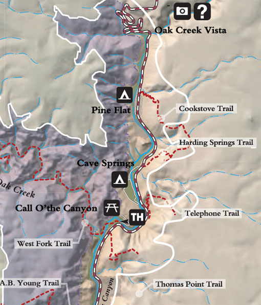
Location: 17 miles south of Flagstaff (10 miles north of Sedona) on paved roads in scenic Oak Creek Canyon.
Access: Drive 17 miles south of Flagstaff or north 10 miles from Sedona to the entrance to Cave Springs Campground at about milepost 385.5. The Harding Springs trailhead is on the east side of the highway. Be careful to take the trail that leads uphill. The other one doesn't go much of anywhere.