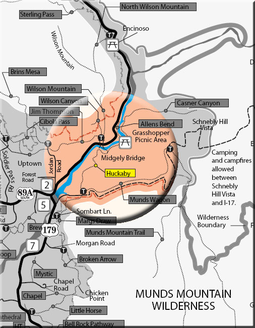
This trail, constructed in 1998, is never far from the sights and sounds of Sedona. It is a pretty trail which offers a variety of views. It can be hiked from the Schnebly Hill trailhead (as described herein) or from Midgley Bridge. The trail is nearly level for 1/8 mile. The Margs Draw trail forks off to the left. Huckaby continues ahead and soon descends rather steeply, crosses Bear Wallow Wash, then ascends moderately over the next 1/2 mile. It tops out on a ridge and winds on level ground with nice views over Oak Creek and Uptown Sedona to many of the familiar red rock formations of the area.
At the 1 mile point, the trail curves around the top of Mitten Ridge with Steamboat Rock, Wilson Mountain and Midgley Bridge coming into view beyond the creek below. Then, it begins a moderate descent over the next 1/2 mile to the floodplain of Oak Creek. the trail goes north beside the creek for 1/2 mile in the partial shade of the riparian trees.
At 2 miles, opposite the north end of Midgley Bridge, the trail crosses a branch of the creek which requires wading or boulder hopping. Do not cross if the water is high. The trail continues north for 0.2 miles, then another boulder hop of the west branch is needed. The trail now climbs moderately over switchbacks, passes beneath Midgley Bridge, and ends at the parking area at the north end of the bridge. The trails is mostly unshaded except along the creek and can be hot in summer. Return by the same route or do one way in either direction with arranged transportation.
Rating: Moderate
Use: Moderate
Hiking time: allow 3 hours for round trip
Notes: This trail NOT recommended for horse traffic.
At a Glance
Open Season:
Year 'round
Usage:
Medium-Heavy
Closest Towns:
Sedona, AZ
Operated By:
Red Rock Ranger District - 928-203-2900
General Information
Latitude: 34.866110
Longitude: -111.748562
Length: 2.6 miles
Elevation: 4465 at TH off of Schnebley Hill
General Notes:
Directions:
USGS Maps: Munds Park, Munds Mountain and Sedona
Access: From the trailhead at Schnebly Hill - At the junction of Routes 89A and 179, take 179 south .3 miles. Turn left on Schnebly Hill Road just across the Oak Creek Bridge and go .8 miles. Take the turnoff on the left signed for Margs and Huckaby trails. Trail directional signs begin by the kiosk. (GPS Schnebly Trailhead: N34° 51' 58.032", W-111° 44' 54.7794")
From the trailhead at Midgley Bridge (Midgley GPS: N34° 53' 7.7634", W-111° 44' 29.616") - Take Hwy. 89A north from the Hwy 89A and Hwy 179 junction for 1.9 miles to north end of Midgley Bridge. Parking area on left (north west of the highway). The Trail begins beneath the bridge.