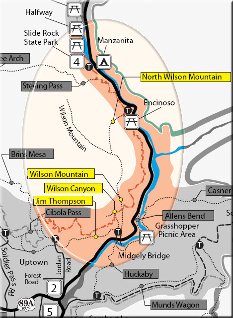
This trail can be hiked from either the Wilson Canyon Trailhead (as described here) or the Jordan Road Trailhead (see map below). From Midgley Bridge parking area, start along the road past the picnic ramada. At .1 miles, bear right onto the trail marked by large rock cairns. It gradually climbs, then descends to the canyon drainage. At .6 miles, pass the fork signed for Wilson Mountain Trail and 100 yards further, take the left fork signed for Jim Thompson Trail. It immediately begins a .2 mile moderate climb. Bear right as you top out and after 100 yards, take the left fork (to the right is a path onto Steamboat Rock). The trail is wide and nearly flat with sparse shade as it follows an old road along the base of Steamboat Rock and past Steamboat Tank on the right at 1.5 miles. Nice views.
At 2.25 miles, the trail passes through a cattle gate, becoming narrower and more shaded as it gently descends into Mormon Canyon. At the bottom, the trail bends right into the canyon a short way before joining the start of Brins Mesa Trail on a closed road at 3 miles. The Jordan Road Trailhead parking area is 150 yards south (left) down the road just past the gate. Return by the same route for a 6 mile roundtrip hike or hike one way in either direction with arranged transportation.
Rating: Easy
Hiking Time: Allow 3.5 hours roundtrip
Uses: Hiking, horses, mountain bikes
At a Glance
Usage:
Heavy
Closest Towns:
Sedona, AZ
Operated By:
Red Rock Ranger District - 928-203-2900
General Information
Latitude: 34.888280
Longitude: -111.768354
Length: 3 miles
Elevation: 4533
Directions:
USGS Map: Munds Park/Wilson Mountain
Location: 38 miles south of Flagstaff in scenic Red Rock Country.
Access:
Wilson Canyon Trailhead: From the junction of Routes 89A and 179, take 89A north 1.9 miles to the parking area on the left at the north end of Midgley Bridge.
Jordan Road Trailhead: (GPS: N34° 53' 17.952", W-111° 46' 6.132") From the junction of Routes 89A and 179, take 89A north .3 miles to Jordan Road on the left. Follow Jordan Road into the Jordan Park subdivision and turn left onto Park Ridge Drive at the "T". Continue .4 miles to parking near the gate at the end of a short stretch of unpaved road.