The Lime Kiln was constructed during the mid 1880’s to burn limestone and create lime for the mortar used in the construction of the Willard House and the Strahan house. The kiln is believed to have been built by Charles and G.M. “Mack” Willard, “the Willard Boys” who built the house in Cottonwood for their widowed mother, Mary. Charles Willard is recognized as the “Father of Cottonwood”. The Kiln was excavated out of a limestone ledge in the White Hills above Cottonwood. The front was closed with rock and mud mortar, and the top is open. Today, the kiln is about 6ft. high but it originally stood as high as 20 feet and had a solid cap.
The Lime Kiln Road was constructed at the same time as the kiln to bring lime from the kiln to the Willard and Strahan house construction sites. Eventually the road continued beyond the Lime Kiln to connect into the Oak Creek Road, and became known as the Lime Kiln Cut-Off. This route became a favorite route for early settlers of the upper Verde Valley because it was considerably shorter than the main road. The road was constructed for horse and wagon use and was abandoned by the time automobile use became popular (Willard 1979).
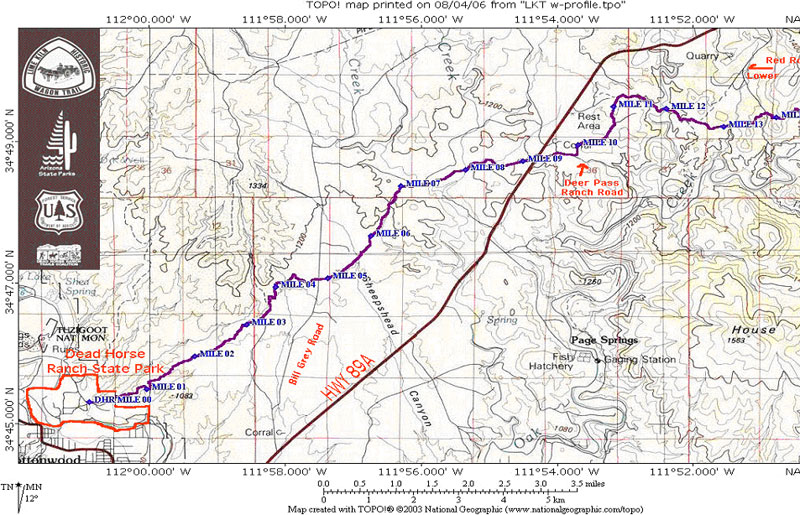
The Lime Kiln Trail is 15 miles long. Nine miles are non-motorized and six miles are motorized.
Access points include Dead Horse Ranch State Park, The Bill Grey Road, Hwy 89A, The Deer Pass Road (FR 89B), Lower Red Rock Loop Road and Red Rock State Park.
In 2005 the trail was listed as a Centennial Trail by the USDA Forest Service, in celebration of the 100th birthday of the US Forest Service.
Rating: Strenuous
Uses: Hiking, horseback riding, cycling (on part of it).
For more information contact:
Red Rock Ranger District, P.O. Box 20429, Sedona AZ 86341, (928) 282-4119 or
Dead Horse Ranch Trails Coalition, 2011-B Kestrel Road, Cottonwood, AZ 86326, (928) 639-0312
Ken Anderson, Former District Ranger of the Red Rock Ranger District
After a century of rest, the historic Lime Kiln Trail, a local dream and concept, will once again provide an inter-community connection here in the Verde Valley. In addition to its local significance, the Lime Kiln Trail concept was recognized by the White House Millennium Council in 2000 as a National Millennium Community Trail to "connect the people to their land, their history and their culture." Since this time, exciting new coalitions have been formed to re-create this inter-community trail utilizing state, county, federal and strong community partnerships.
According to Diane Lovett, horse woman and trail founder, "It has been almost twenty years since several other riders and I first discovered the old Lime Kiln Trail alignment. We began asking some old timers to share their stories about the trail and began talking with the Forest Service about the trail idea. It has been a long and worthwhile process, a 'dream come true' to see it now becoming a reality."
Early settlers like Charles Willard used the Lime Kiln and its bricks for which the trail is named, to build brick homes here in the valley. The Lime Kiln Cut-Off was a major travel route between the mining town of Jerome and the Oak Creek farming community of Sedona. Horse drawn wagons and carts transported bricks, Oak Creek wine and locally grown produce for trade between these Verde Valley communities.
The new 14 mile Lime Kiln Trail will provide an excellent historic trail opportunity for equestrian riders, mountain bicyclists and hikers connecting Dead Horse Ranch State Park in Cottonwood to Red Rock State Park in Sedona. The trail is designated as non-motorized, although portions of the trail follow existing road alignments.
Directions:
The Lime Kiln Trail is 15 miles long. Nine miles are non-motorized and six miles are motorized. Access points include Dead Horse Ranch State Park, The Bill Grey Road, Hwy 89A, The Deer Pass Road (FR 89B), Lower Red Rock Loop Road and Red Rock State Park.