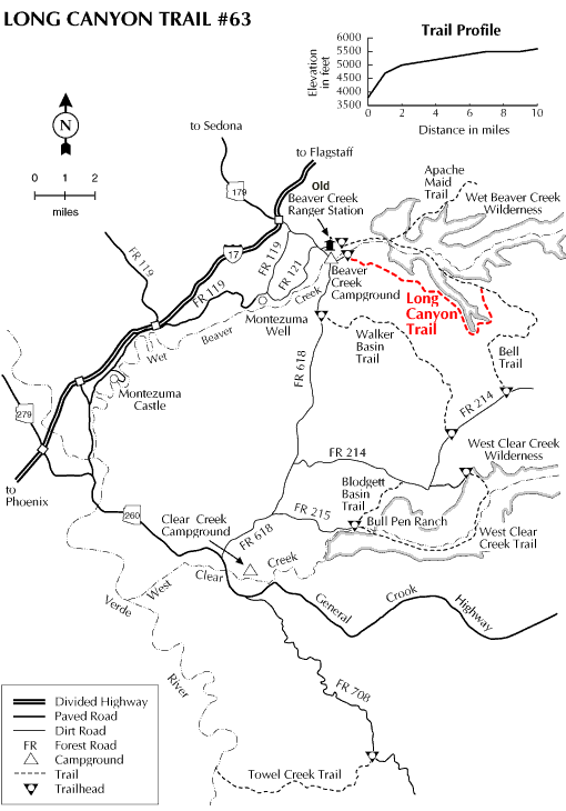
This trail starts upstream of the Beaver Creek Campground and switchbacks up to the top of the mesa providing glimpses of the Verde Valley and the red rock country of Sedona on the way. Once on the mesa, the trail levels out and affords a panoramic view of the surrounding country, including the San Francisco Peaks to the north. The trail trends in a southeasterly direction and climbs again to the top of the Mogollon rim. Once on the rim, the trail may be indistinct and thus hard to follow.
Look for the rock cairns that mark the route. The trail passes by Long Canyon Tank, which provides the only source of water on the trail. Vegetation removal on the rim has left forested "fingers" that provide important cover for wildlife. Watch for elk, antelope, and deer in these areas of mixed forest and grassland. The trail crossed the road that runs to the east of Long Canyon Tank and enters the forested area along the edge of Long Canyon.
This area was utilized by the prehistoric Sinagua culture and artifacts and habitation sites may be found. Remember that Federal law prohibits the removal of artifacts and the damaging of archeological sites. Leave any artifacts found for the enjoyment of others and take only photographs. The trail continues southeasterly following the canyon and crosses the north and south forks of Long Canyon before heading north to junction with the Bell Trail #13. Be sure to bring a topographic map of the area, compass and plenty of water when hiking this trail.
Rating: More difficult
Hiking time: 6 hrs
Notes:
Portions of the trail may be hard to find so the use of a map and compass is advised.
There is no water available on the trail, other than the stock tank, so carry plenty with you on your hike.
At a Glance
Open Season:
Year 'round
Usage:
Light
Closest Towns:
Camp Verde and Sedona, AZ
Operated By:
Red Rock District - 928-203-2900
General Information
Latitude: 34.675644
Longitude: -111.701469
Length: 9.5 miles
Elevation: 3906 at trailhead
General Notes:
Directions:
USGS Map(s): Apache Maid Mtn, Casner Butte.
Location: 53 miles southeast of Flagstaff on paved and graveled roads in scenic red rock country.
Access: Drive 40 miles south from Flagstaff on Interstate 17. Leave the interstate at the AZ 179 interchange (exit #298). Turn east under the highway and drive about 2.5 miles east on FR 618. Turn left (east) on the very first road past the creek (Beaver Creek). Travel 0.75 miles to the trailhead located on the right side of the road.