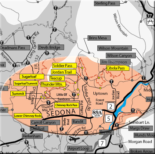
Lower Chimney Rock, Summit, Chimney Rock Pass, Thunder Mountain Trails
The North Urban Trail System is an interconnected series of trails along the red rock front country at the north edge of Sedona. The western portion, described here, includes the above listed trails. These trails may be reached using the three trailheads shown below under "access" or from the Teacup Trail from the west.
An easy 1.4 mile loop can be made from the Thunder Mountain Trailhead using Lower Chimney Rock Trail and the southern portion of the Thunder Mountain Trail. From the loop, a short but steep route climbs up the Summit Trail to Chimney Rock Vista on top of a red rock hill with a great 360 degree view. A moderate 2.6 mile loop can be made using the Chimney Rock Pass Trail and more of the Thunder Mountain Trail. or, a moderate "figure 8" of 3 miles can be hiked using the same trails. The trailhead at the north end of Andante Drive can also be used as the starting point for these loops. These trails offer no shade.
The Thunder Mountain Trail is the connector between these western trails and the eastern portion of the North Urban Trail System (described separately). The trail begins at the Thunder Mountain Trailhead and goes north, passing Chimney Rock. It then turns east and crosses the open area south of the sheer face of Capitol Butte, intersecting Teacup Trail at 1.7 miles. This is an easy, level trail, but there is no shade. The Teacup trail continues east. The Sugarloaf Trailhead is .3 miles to the south.
Rating: Easy / Moderate
Hiking Time: 1 to 3 hours, depending on route used
Uses: Hiking, bicycling, horses (Bicycles prohibited on Chimney Rock Pass Trail in Wilderness; bikes not recommended for Summit Trail due to steep and hazardous conditions.)
USGS Map: Wilson Mountain/Sedona
At a Glance
Open Season:
Year 'round
Usage:
Medium-Heavy
Operated By:
Red Rock District - 928-203-2900
General Information
Latitude: 34.870880
Longitude: -111.81138
Length: 1.5 to 5 miles, depending on route used
Elevation: 4517 at Thunder Mtn. trailhead
Directions:
Location: 38 miles south of Flagstaff in scenic Red Rock Country.
Access:
Thunder Mountain Trailhead - From the junction of Routes 89A and 179, take 89A west 3.2 miles to Dry Creek Road on the right. Go north .5 miles to Thunder mountain Road on the right. Go .6 miles east to the turnoff on the left for trailhead parking. GPS: N34° 52' 14.5194", W-111° 48' 40.86"
Andante Drive Trailhead - From the junction of Routes 89A and 179, go west 2.5 miles to Andante Road on the right. Go north 1.2 miles to end of road and small trailhead parking area on left next to water storage tank. Follow spur trail west 120 yards to the Thunder Mountain Trail.
Sugarloaf Trailhead - from the junction of Routes 89A and 179, take 89A west 2 miles to Coffee Pot Drive on the right. Go .5 miles to Sandborn Drive on the left, then .02 miles to Little Elf Drive on the right. Go .2 miles to the end of Little Elf and turn right on Buena Vista Drive for 50 yards to the trailhead parking area on the left.