The hike up the Parsons Trail is a pleasant stroll along a cool, clear desert stream set in a magnificent red rock canyon. Sycamore Canyon is a place sufficiently unique to have been one of the first areas protected as wilderness in Arizona. The trail leads through the lower reaches of this wilderness through a riparian area rich in plant and animal life.
Colorful cliffs that are a unique mix of dark columnar basalt, red sandstone, and buff colored limestone enclose the lush green of the oasis. The trail leads 4 miles to a large pool called Parson Springs where this considerable stream springs to the surface from the underground course it has followed through the majority of the canyon. Up canyon from this point surface flow only occurs during snowmelt and after summer monsoons.
The limestone layer just above the streambed is riven with small caves. Flat ledges of red sandstone extend to the water's edge. Songbirds flit through the tall cottonwoods and thick mesquite bosques. At a number of points additional springs flow from the canyon walls through gardens of columbine and watercress. All these features combine to make this trail one of the most popular, and one of the most crowded, on the forest. If you visit this truly exceptional place please exercise extra discretion in making sure the impact you create is as slight as possible.
Rating: Easy
Hiking time: 5 hours round trip
Notes:
No mechanized vehicles in Wilderness.
No camping is permitted in the first 4 miles of the canyon. Camping is allowed 200 feet north of Parsons Springs.
The trail is a bit hard to find in some places and a few washed out sections require some boulder hopping.
At a Glance
Open Season:
Year 'round
Usage:
Heavy
Closest Towns:
Clarkdale, AZ
Operated By:
Red Rock District - 928-203-2900
General Information
Directions:
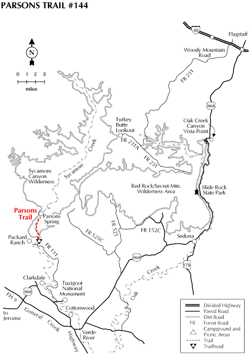
USGS Map(s): Clarkdale S. E., Sycamore Basin
Location: 76 miles south of Flagstaff (33 miles south of Sedona) on paved and graveled roads.
Access: Drive 65 miles south from Flagstaff on US 89A through Sedona and Cottonwood to the turnoff to Tuzigoot National Monument. Turn north across the Verde River, then left on FR 131. It's about 11 miles to the trailhead.