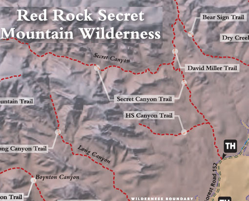
The Secret Canyon Trail is of moderate length, leading into the Wilderness. The first two miles follows an old road bed, that is fairly flat and easy going. The rest of the way, the trail meanders in and out of the canyon bottom. Vegetation varies from chaparral to mixed conifer along this typically dry water course.
The signed trailhead is across the usually dry streambed of Dry Creek west of the parking area. The trail immediately enters Wilderness. The wide, nearly flat trail leads into the wide canyon mouth with nice views, but no shade from the desert scrub vegetation. At 2/3 mile, HS Canyon Trail branches off to the left. Continue ahead for Secret Canyon. At 2 miles, continue ahead (west) as the trail drops down to cross a drainage. It climbs gently for the next 3 miles beside the canyon drainage, frequently dipping down to cross it.
There is shade from oak and ponderosa and nice views of red rock formations. At 5 miles, the streambed turns sharply left a short distance to an interesting "chute". Return to the trail which continues ahead, climbs sharply, then levels out. At 5.5 miles, there is a deep ravine and a series of pools in the solid rock streambed. An unmaintained trail continues on. Return by the same route for an 11 mile hike. The hike can be shortened and still be worthwhile. The trail can be very hot in summer.
Uses: Hiking, horses. (Bicycles prohibited in Wilderness)
Hiking time: Allow 6 hours round trip
At a Glance
Open Season:
Year 'round
Usage:
Medium-Heavy
Closest Towns:
Sedona, AZ
Operated By:
Red Rock Ranger District - 928-203-2900
General Information
Latitude: 34.9304
Longitude: -111.8072
Length: 5.5 miles
Elevation: 4673
Directions:
USGS Map: Wilson Mountain
Location: About 42 miles south of Flagstaff (12 miles west of Sedona) on paved and graveled roads.
GPS: N34° 55' 48.1434", W-111° 48' 24.084"
Access: Drive 27 miles south from Flagstaff to Sedona on US 89A. Continue through Sedona to Dry Creek Road (152C) at the west end of town. Turn right on Dry Creek Road and drive for two miles to Forest Road 152. This road is rough; high clearance vehicles recommended. It is not recommended during wet weather. About 3 miles up this road on the left (west) side of the road is a two-track road. Turn onto this road. There is a trailhead sign at the junction of these two roads. The parking area is approximately 200 feet behind the sign.