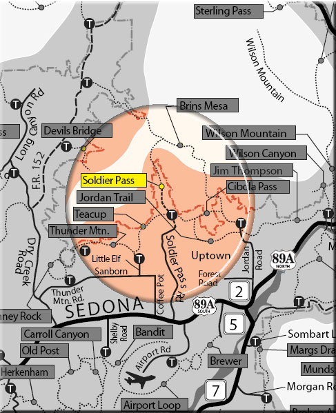
This trail provides a diverse experience beginning in an urban setting and eventually leads into Red Rock Secret Mountain Wilderness, increasing the potential for solitude. The first half of this trail is often busy and there is jeep tour traffic nearby (see photo lower right). Enter at the signed trailhead which is open only from 8 a.m. to 6 p.m. The trail dips to cross a wash then climbs out to the Devils Kitchen sinkhole just off the trail to the right at 1/4 miles. The trail then goes over level ground for 1/4 mile to the "Seven Sacred Pools" to the left of the trail.
It continues on in the partial shade of Arizona cypress and intersects the end of a jeep road at 1.2 miles. The trail forks at the wilderness area boundary sign 1/8 mile further on. The right branch leads up rather steeply for 1/4 mile to an arch. Great views. The left branch is the main trail. This leads out of the wash on a moderate grade. Most of the shade is lost, but the views open up. The trail becomes increasingly steep and rocky as it climbs to the pass. Nearing 2 miles, it levels out on top of Brins Mesa, then continues for another 1/4 miles where it intersects Brins Mesa trial. Ultimately, scenic vistas can be enjoyed south into Sedona and north into the wilderness and the red cliffs of the Mogollon Rim. Return by the same route for a 4.5 mile round trip hike.
Rating: Moderate
Uses: Hiking, horseback riding, biking (bicycles allowed only for the first 1.3 miles to Wilderness Boundary)
Hiking time: allow 2.5 hours roundtrip
Note: Bicycles prohibited in the wilderness
At a Glance
Open Season:
Year 'round
Usage:
Medium
Closest Towns:
Sedona, AZ
Operated By:
Red Rock District - 928-203-2900
General Information
Latitude: 34.884247
Longitude: -111.783848
Length: 2.4 miles
Elevation: 4451 at trailhead
General Notes:
Directions:
USGS Maps: Wilson Mountain
Location: 28 miles south of Flagstaff (1 mile north of Sedona) on paved and dirt Forest roads in scenic red rock country.
GPS: N34° 53' 3.372", W-111° 47' 1.752
Access: From the junction of Routes 89A and 179, take 89A west 1.2 miles to Solider Pass Road on the right. Go 1.5 miles to Rim Shadows Drive, then right 0.2 miles (keep straight ahead where Rim Shadows branches left) to a gated entry road to trailhead parking on the left.