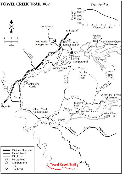
This trail is unique among those on the Coconino National Forest. It leads through an area of picturesque buttes and low bluffy mountains that is quite different from that along any other trail on the forest. It is also one of the few trails on the Coconino that leads to the Verde River, a great place to camp out or cool your feet before starting back to the trailhead.
The main vegetation type in this rugged country is high chaparral. It consists mostly of manzanita, scrub oak, and cliffrose. There are hackberries here too, for which nearby Hackberry Mountain is named. Cottonwoods, sycamores and willows cluster near the few seeps and springs, while stands of pinyons and junipers cling to the higher elevations.
The Towel Creek area has been grazed since the latter half of the nineteenth century. Along the trail, you'll see evidence of its cattle growing past, present, and even its future. One thing you might notice is that the grass cover is comparatively healthy here in spite of its being grazed. That's the result of a progressive management program being used by the local rancher. The Towel Creek Trail is used to move cattle between seasonal ranges.
About 3 miles from the trailhead, a short side-hike leads to Towel Spring. 3.5 miles further along you'll see an old line shack which is still used by cowboys. From here it's two more miles to the Verde River and its cool waters.
At a Glance
Open Season:
Year 'round
Usage:
Light
Closest Towns:
Strawberry and Camp Verde, AZ
Operated By:
Red Rock District - 928-203-2900
General Information
Latitude: 34.434658
Longitude: -111.687271
Length: 6.4 miles
Elevation: 4150 at trailhead
General Notes:
Rating: Moderate
Hiking time: 3 hours
Note:
No motor vehicles
Directions:
USGS Map(s): Hackberry Mtn. Horner Mtn.
Location: 65 miles south and east of Flagstaff (14 miles east of Camp Verde) on paved and graveled Forest Roads.
Access: Drive 50 miles south of Flagstaff on Interstate 17 and take the Middle Verde exit. Drive east through Camp Verde on Forest Highway 9 and continue about 6 miles to FR 708. Turn southeast on FR 708 about 9 miles to the trailhead near Needle Rock.