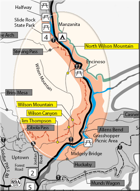
This trail begins at the picnic ramada just up the old roadway from the Midgley Bridge parking area. At .1 miles, bear right onto the trail marked by large rock cairns. It gradually climbs, then descends to the normally dry canyon drainage. At .6 miles, past the fork to the right signed for the Wilson Mountain Trail and then the fork to the left signed for the Jim Thompson Trail. Continue ahead, entering the Wilderness area in the partial shade of live shrub oak and small Arizona cypress.
Views are now limited to the tops of the canyon walls and the upper portion of Wilson Mountain ahead. Nearing 1.5 miles, the trail enters the drainage and proceeds over red rock with an occasional rock scramble in the shade of large Arizona cypress. At 1.5 miles, there is a red rock outcrop on the right. A side path climbs this and continues a short way, ascending about 100 feet to a saddle offering excellent views. This is a good place to turn around and return by the same route for a 3 mile roundtrip hike.
Hiking Time: Allow 2.5 hours roundtrip
Uses: Hiking only. Not recommended for horses; bicycles prohibited in Wilderness
At a Glance
Open Season:
Year 'round
Usage:
Medium-Heavy
Closest Towns:
Sedona, AZ
Operated By:
Red Rock District - 928-203-2900
General Information
Latitude: 34.887390
Longitude: -111.742117
Length: 0.6 miles
Elevation: 4535 at trailhead
Directions:
USGS Map(s): Red Rock-Secret Mountain Wilderness
Location: 38 miles south of Flagstaff in scenic Red Rock Country.
Access: From the junction of Routes 89A and 179, take 89A north 1.9 miles to the parking area on the left at the north end of Midgley Bridge.