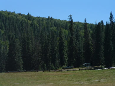
Arizona's Best Swimming Holes  


KP Cienega Campground

Statistics Elevation
 8980'
Season
May - Sept.
Days Limit
14
Fee
No
Units
5
Trailer Limit
16'
GPS Location
 33° 34' 33"N
109° 21' 18.13"W
Access
 Paved
 
Amenities Potable Water
 Spring Fed
Waste Disposal
No
Restrooms
Vault
Showers
No
Reservations
No
Store Nearby
Hannagan
Campsite Grills
Yes
Campsite Tables
Yes
Fire Rings
Yes
Utility Hookups
No
Information
928 333-4301
Firewood
Alpine
Fishing Supplies
Alpine
Laundry
Springerville
Gas & Propane
Hannagan
ATV Use
No
Visitor Center
No
 
 
Fish Species Rainbow Trout
Yes
Cutthroat Trout
-
Brook Trout
-
Brown Trout
-
Apache Trout
-
Crappie
-
Yellow Bass
-
Flathead Catfish
-
Tilapia
-
Yellow Perch
-
Carp
-
Redear Sunfish
-
Bluegill
-
Green Sunfish
-
Walleye
-
Northern Pike
-
Channel Catfish
-
Sunfish
-
Smallmouth Bass
-
Largemouth Bass
-
Striped Bass
-
White Bass
-
Arctic Grayling
-
Bullhead
-
Fly and Lure Only
-
Acreage
-
Body of Water Depth
-
Catch and Release Areas
-
Boats Allowed
No
Motor Limit
-
Boat Rentals
-

Tell a friend

KP Cienega lies in a meadow just north of the Blue Vista (see image below).

KP Cienega Campground turnoff is located 4.6 miles south of Hannagan Campground on scenic U.S. route 191. A small campground with only 5 units, KP is next to the small KP Creek which holds some small trout. KP Creek begins in a nearby spring and flows through the wonderfully green meadow that the campground sits in.

There are several hiking trails in the surrounding mountains and some that lead into the Bear Wallow Wilderness and the Blue River Canyon in the Blue Primitive Area.

There is a restaurant and country store with very limited supplies in Hannagan Meadows. The next closest services are in Alpine. The vault style restrooms are handicap accessible.

4WD vehicles can try out the roads 1.6 miles south from the campsite. 
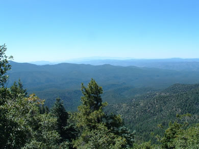
For 175 mile views, check out the Blue Vista View point area 1.5 miles to the south of the KP turnoff. You can see as far south as Mount Graham 70 miles away as the crow flies or Humphrey's Peaks 175 miles away.

Directions

From Alpine travel south on U.S. route 191 27 miles to the turnoff then 1.3 miles to the campground.


You can see from Mt. Graham all the way north to the San Fransisco Peaks from Blue Vista.
Mt. Graham (very faint in the middle of the picture) from the Blue Vista Viewpoint

Comments

comments powered by Disqus


Campsite Ratings
Overall Rating

Available Amenities

Cleanliness

Fishing

Campsite Spacing
1- Tight 5- Spreadout

Camp Host

Good for Kids

Other Nearby Campgrounds

Strayhorse
Hannagan
Blue Crossing
Upper Blue
Alpine Divide
Luna Lake

East/West Fork of the Black River Campgrounds

Buffalo Crossing
Horse Springs
Raccoon
Deer Creek
Aspen
Diamond Rock
West Fork

Other Media

Camping Regions
Camping Regions

Central Arizona
Flagstaff / Sedona / Prescott
Northeast / Grand Canyon
Payson / Mogollon Rim
Southeast / Tucson
White Mountains
Western Arizona


Camping
Resources

Camping Checklist
Camping Gear
Our You Tube Videos
Camping Recipies

Arizona Game and Fish Department

Fishing Reports
Lake Levels
Stocking Schedule
AZ Fishing Rules & Regulations
Where to Fish
Sport Fish Species
Urban Fishing

U.S. Forest Service
National Forests in Arizona

Apache Sitgreaves N.F.
Coconino N.F.
Coronado N.F.
Kaibab N.F.
Prescott N.F.
Tonto N.F.


Site Map
Advertising Information
Contact Us
Links


All campground rates and information are subject to change without notice.


Home | Campgrounds | Hiking Info |Camping Checklist | Fire Information
Western Arizona RV Parks | Fishing Reports | Contact Us | Links
Site Map

All original material and HTML coding © 2004-2021 camparizona.com

Terms of Service | Privacy Policy


Arizona Game and Fish Department U.S. Forest Service