Arizona's Best Swimming Holes  


Bear Sign Trail #59

Upload GPS Tracks
Upload Trail Photos

Download this GPS TrackRight Click and "Save Link As.."

Trail Ratings
Overall Trail Rating
1 = Poor 5 = Outstanding

Scenic Views
 
Route Finding
1 = Poor 5 = Excellent
 
Technical Difficulty
1 = Easy 5 = Very Difficult
 
Trail Access
1 = Easy 5 = Hard to get to
 

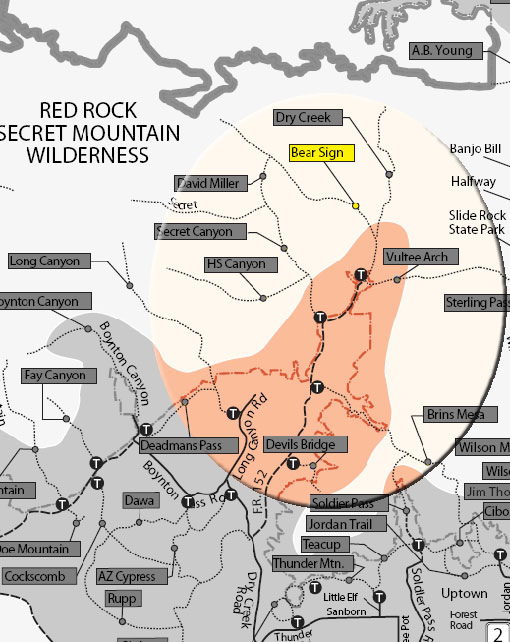
An infrequently used trail that has a true remote feel. It is shady, and can be hiked in summer. Begin on Dry Creek Trail. Its signed trailhead is west of the parking area across a wash. The trail immediately enters Wilderness Area and turns right as it meets Dry Creek and follows along this usually dry streambed.

It climbs out briefly and there is a good view of the area. At .75 miles, there is a junction of two drainage ditches. View along the Bear Sign Trail/Dry Creek continues ahead. Go left past the trailhead sign for Bear Sign. The trail climbs gradually parallel to the drainage with views of the red rock walls of this rugged canyon. later, the trail narrows and becomes less distinct, but is never far from the dry streambed and is marked by cairns. At 3 miles, the trail crosses a large wash, bends right and soon ends in a carpet of ferns with views of white Coconino sandstone cliffs. Return by the same route for a 6.5 mile hike.

Rating: Moderate

Hiking Time: Allow 4 hours roundtrip

Uses: Hiking and Horses; Bicycles are prohibited in the Wilderness Area

USGS Map: Wilson Mountain

See also, Secret Canyon Loop Trails

At a Glance

Open Season: Year 'round
Usage: Light-Medium
Closest Towns: Sedona, AZ
Operated By: Red Rock Ranger District - 928-203-2900

General Information

Latitude:

Longitude:

Length:

Elevation:

General Notes:

Directions:

Location: 38 miles south of Flagstaff in scenic Red Rock Country.

Access: From the junction of Routes 89A and 179, take 89A west 3.2 miles to Dry Creek Road on the right. Go 1.9 miles to FS 152 on the right. Take this unpaved road 4.4 miles to trailhead parking at its end. Forest Road 152 very rough - high clearance vehicles recommended. This road should be avoided in wet weather.

Bear Mountian Trail #54


Comments

comments powered by Disqus


Camping Regions
Camping Regions

Central Arizona
Flagstaff / Sedona / Prescott
Northeast / Grand Canyon
Payson / Mogollon Rim
Southeast / Tucson
White Mountains
Western Arizona


Camping
Resources

Camping Checklist
Camping Gear
Our You Tube Videos
Camping Recipies

Arizona Game and Fish Department

Fishing Reports
Lake Levels
Stocking Schedule
AZ Fishing Rules & Regulations
Where to Fish
Sport Fish Species
Urban Fishing

U.S. Forest Service
National Forests in Arizona

Apache Sitgreaves N.F.
Coconino N.F.
Coronado N.F.
Kaibab N.F.
Prescott N.F.
Tonto N.F.


Site Map
Advertising Information
Contact Us
Links


All campground rates and information are subject to change without notice.


Home | Campgrounds | Hiking Info |Camping Checklist | Fire Information
Western Arizona RV Parks | Fishing Reports | Contact Us | Links
Site Map

All original material and HTML coding © 2004-2021 camparizona.com

Terms of Service | Privacy Policy


Arizona Game and Fish Department U.S. Forest Service