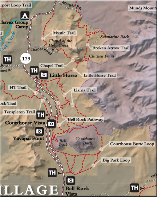
The Templeton Trail, Baldwin Trail, Llama Trail, Little Horse Trail, and Broken Arrow Trail are popular mountain bike trails. Although suitable for hiking, the Llama Trail is an alternate connector between the Little Horse Trail and Templeton trail for mountain bikers wishing to avoid the popular Bell Rock Pathway. The Llama Trail is marked at its intersection with the Little Horse Trail. There is a large dead Pinion Pine tree at the intersection. Before the Llama Trail was marked, bikers carved a broad area around the trail intersection attempting to locate the Llama Trail access. Please stay on the trail so the area can heal. Bikers should take care to use the Bell Rock Pathway to access the Bell Rock Vista parking area. The Court House Loop Trail passes through the Munds Mountain Wilderness where bikes are prohibited. Please respect the protection afforded by wilderness areas on plants and wildlife.
Rating: Moderate
Hiking Time: 5 hours
Cumulative Elevation: 200 ft.
Notes:
Horses are prohibited on Bell Rock Pathway.
A Red Rock Pass is required to park.
Bicycles are prohibited in the Wilderness Area.
Respect private property boundaries.
At a Glance
Open Season:
Year 'round
Closest Towns:
Sedona, AZ
Operated By:
Red Rock District 928-203-2900
General Information
Latitude: 34.891518
Longitude: -111.761600
Length: 2.5 miles
Elevation: 4185
Directions:
USGS Map(s): Sedona, Munds Mtn.
Location: 38 miles south of Flagstaff in scenic Red Rock Country
GPS: Bell Rock Vista: N34° 48' 4.7514", W-111° 46' 7.284"
South Bell Rock Pathway Trailhead: N34° 47' 29.2914", W-111° 45' 41.94"
Access: From the junction of Routes 89A and 179 in Sedona, take 179 south 6.5 miles to a short roadway on the left marked for Bell Rock Vista, milepost 307.1. The trail can also be accessed from the Little Horse Trailhead. From the junction of Routes 89A and 179 in Sedona, take 179 south 3.6 miles to a paved turnout and the Little Horse/BellRock Pathway trailhead parking is on the left (east) at milepost 309.8, .2 miles south of the entrance to the United Methodist Church.