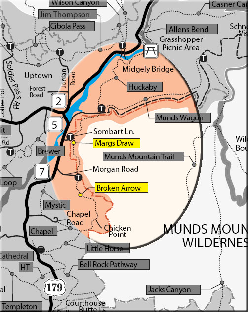
This scenic trail can be hiked from the Broken Arrow Trailhead (as described here), from the Sombart Lane trailhead, or from Schnebly Hill. From Broken Arrow, it begins by crossing the wash just north of the parking area and enters Wilderness. Shade is soon left behind and nice red rock views open up as the trail winds its way north across a nearly flat expanse dotted with juniper, pinyon pine and Arizona cypress. The trail crosses the draw by a scenic dry waterfall at the .75 mile point.
Nearing one mile, a half-mile long spur trail comes in on the left from the trail access at the end of Sombart Lane. Continue ahead. Soon, Uptown Sedona, Capitol Butte, Wilson Mountain and Steamboat Rock come into view. At 1.25 miles, the trail curves around the base of Camel Head and there is a good view of that formation and of Snoopy Rock above and to the right. The trail leaves Wilderness, crosses Schnebly Hill Road, and goes east about .8 mile before ending at a large parking turnout. Return by the same route or hike one way with arranged transportation. The hike can be extended to the north using Huckaby Trail and to the south using Broken Arrow Trail.
Rating: Easy
Hiking Time: Allow 2 hours roundtrip
Uses: Hiking and horses (No bicycles allowed in Wilderness)
At a Glance
Open Season:
Year 'round
Usage:
Light-Medium
Operated By:
Red Rock District - 928-203-2900
General Information
Latitude: 34.845551
Longitude: -111.75686
Length: 2 miles
Elevation: 4285 at Broken Arrow Trailhead
Directions:
Location: 30 miles south of Flagstaff in scenic Red Rock Country.
USGS Map(s): Sedona and Munds Mountain
Access:
From the Broken Arrow Trailhead: From the junction of Routes 89A and 189, take 179 south 1.4 miles to Morgan Road on the left (east). Go .6 miles to end of pavement, cross the cattle guard and continue for another 80 yards to trailhead parking on the left.
Sombart Lane Trailhead: From the junction of Routes 89A and 179, take 179 south .7 miles to Sombart Lane on the left. Follow Sombart for .1 miles to signed trailhead parking area on the left.
Schnebly Hill Trailhead: From the junction of Routes 89A and 179 south .3 miles. Turn left on Schnebly Hill Road just across the Oak Creek Bridge and go .8 miles. Take the turnoff on the left signed for Margs and Huckaby trails. Trail directional signs begin by the kiosk.