Tell
a friend

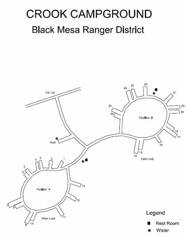
Woods
Canyon Lake, the most popular camping area in the entire
state, has much to offer. Virtually every amenity is either
available on site or within a few miles. The Crook
Campground set just 3/4 mile back from the lake
and has 26 campsites. There are two loops at Crook, each able to hold a large group of campers
Located
at the lake is a country store complete with boat rentals
and a battery charging station for those who bring their
own trolling motors. The store pretty much has everything
you might need for a great camping trip. A phone is available
at the front door of the store.
Just
around the corner from the store is the Rocky Point day
use area. There is a charge to use the parking area but
it is minimal ($5.00). There is good fishing down by Rocky
Point and I tend to spend at least one afternoon there
every visit.
A
dump station is located just up the road.
The
Rim Visitors Information Center is located at the junction of
the S. R. 260 and Rim Road.
Showers
are located at Canyon Point
Campground 5 miles east of the visitors center on
S. R. 260. The charge for using the showers is $5.00.
Fishing Information
If fishing for trout, try power bait from the shore, try power bait or worms. Boaters can try trolling Super Duper or tiny gold Kastmaster lures. When it is hot during the summer, fish a little deeper, but not too deep, between 10 to 20 feet because the lake stratifies in the summer, meaning there is no oxygen at the bottom. The lake is loaded with crayfish, try fishing for big browns int he spring and fall with spinners or lures that imitate crayfish patterns. Lake depth averages 25 feet and can reach up to 40 feet.
Statewide fishing regulations apply and a trout stamp is required. The daily bag limit is six trout, three for unlicensed anglers under the age of 14.
Cow bells or bumble bee's can also bring good results.
I fly fish the lake and notice that many fly fisherman tend to use sinking line with a bead head wolly bugger in olive or black. I have good luck when the shade hits the shores to the left of the boat dock down the left arm of the lake down along rocky point day use area with small dry flies like a parachute adams or any type of caddis.
Nearby Hiking
Woods Canyon Lake Trail surrounds the lake and makes for a nice but easy afternoon hike.
Click for a map of trails in the Black Mesa Ranger District

Directions
From
Payson, travel east on U.S. 260 until you reach the top of the
Mogollon Rim and turn left on F. R. 300 (Rim Road). Travel west
on Rim Road 3.4 miles to the Rec. Area entrance. Turn right at
the entrance and travel 0.5 miles to the campground on the Right.
Don't forget to stop by the scenic stops along Rim Road for spectacular
views of the Mogollon Rim and the valley below.
Campsite Panoramas - See each campsite at Christopher Creek Campground.
Click a campsite number below
1, 2, 3, 4, 5 & 6, 7 & 8, 9 & 10, 11, 12 ,13 ,14 & 15, 16, 17 & 18, 19, 20, 21, 22, 23, 24, 25 & 26, Picnic Shelter South, Picnic Shelter North